by Zack Leasor, State Climate Extension Specialist & Assistant Professor, University of Missouri
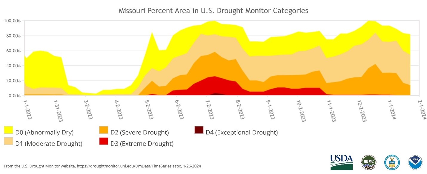
Drought is common in Missouri, and the impacts are often felt across various sectors, including agriculture, water resources, ecology, energy, human health, and the economy. 2023 was no exception, as it was the second consecutive year with widespread drought conditions observed across the state. Looking back at 2023, all of Missouri experienced conditions ranging from abnormally dry (D0) to exceptional drought (D4) based on drought severity classifications from the United States Drought Monitor (USDM) (Figure 1). According to USDM, the state had yet to observe drought severity coverage to this extent since 2012.

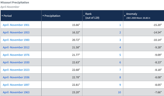
Comparing the most recent drought event with Missouri’s historical climate data, the eight-month stretch from April to November 2023 was the state’s 7th driest growing season back to 18951 (Table 1). The statewide average precipitation was 22.68” during this time, 8.18” below normal. 2023 was also Missouri’s third warmest year on record, and above-average temperatures helped to exacerbate drought conditions.

The full story of 2023’s drought begins in 2022, when drought conditions quickly emerged in July and persisted through the end of the year. Fortunately, the state received beneficial rainfall in November and December, and by the start of 2023, only 12.51% of Missouri remained in drought. Above-average precipitation continued in January and February, and drought conditions were nearly eliminated by March. Drought recovery was short-lived as the state recorded the fourth driest April on record, with Henry (0.80”) and Benton (0.85”) counties recording their driest April since 1895. While dry conditions were initially helpful for early spring planting, agricultural concerns were already rising by the end of the month. The limited reprieve from 2022’s drought left some parts of the state with lingering precipitation deficits and a lack of surplus water in soils and farm ponds. The state was left vulnerable to rapid drought onset in 2023 without excess moisture to serve as a buffer.
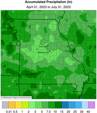
The American Meteorological Society defines flash drought as “an unusually rapid onset drought event characterized by a multiweek period of accelerated intensification.” Many areas were experiencing the rapid onset and intensification associated with flash drought by May 2023, as monthly precipitation was well below average for a second consecutive month. Widespread agricultural impact reports noted sharp declines in soil moisture along with poor pasture conditions and low water levels in ponds and creeks. By early June, large portions of central and northeast Missouri were already classified in severe (D2) or extreme drought (D3) by USDM. Drought conditions continued to persist and expand as Missouri recorded the 6th driest June. With April, May, and June 2023 all ranking in the top 20 driest respective monthly records, some of the driest locations received as little as approximately 3” of rainfall during the three months (Figure 2). Missouri received 440 drought impact reports in June through the National Drought Mitigation Center’s Condition Monitoring Observer Reports (CMOR) tool3. More crop stress was reported alongside continuing livestock and forage issues and declining streamflow. Governor Mike Parson signed an executive order declaring a drought alert and activating the state’s Drought Assessment Committee on May 31, 20234.

July started dry, with widespread fireworks and burn bans announced in time for the Fourth of July weekend. Governor Parson’s Drought Assessment Committee announced emergency plans for water and hay access to alleviate agricultural impacts. By mid-to-late month, however, several heavy rainfall and thunderstorm events provided relief from drought conditions during a critical time for corn and soybean progress. The state eventually recorded above-average precipitation in July, with flash flooding even occurring in some drought-stricken areas of southeast Missouri. This wetter period continued into the first half of August, with the state recording its 9th wettest August. Mississippi (11.83”) and Scott (11.25”) counties in southeast Missouri observed their wettest August on record. While rainfall helped improve crop and streamflow conditions, much of the state remained behind on growing season rainfall. Livestock sales were abundant due to a lack of forage and elevated hay prices.
After an exceptionally wet period from mid-July to mid-August, dry conditions returned to Missouri throughout the fall of 2023. September, October, and November all featured below-average precipitation and above-normal temperatures in Missouri, making it the state’s 14th driest fall. Even though seasonal changes reduced evapotranspiration and atmospheric water demand, the continuing lack of precipitation led to severely limited fall pasture growth, livestock heat stress, and early senescence observed in mature trees. Coinciding with harvest season, extremely low water levels on the Mississippi River negatively impacted commercial navigation in the region. The Mississippi River at New Madrid recorded a new record low stage of -6.55 feet on 10/15/2023. Farmers also had to navigate increased wildfire fire risk as crops were harvested in dry fields.
For the second time in 2023, a streak of three consecutive months with below-average precipitation was broken in December, as the state received slightly above-average monthly precipitation. Missouri’s drought severity coverage has been steadily declining since mid-December, with the percentage of the state classified in at least moderate drought reducing from 83.78% on December 19 to 54.40% on January 25. Continued improvement is owed to several significant winter weather and precipitation events in January. Even though there have been periods of extreme cold, above-average temperatures at the beginning of winter have kept frozen soils from penetrating below surface layers, allowing for much-needed winter soil moisture recharge. While winter has brought drought relief to Missouri, there are still significant precipitation deficits across the state data indicates that soil available water content is still lower than this time in 2023. It is critical to recharge soil moisture and agricultural water supply before the 2024 growing season so the state is not again vulnerable to rapid drought onset and intensification.
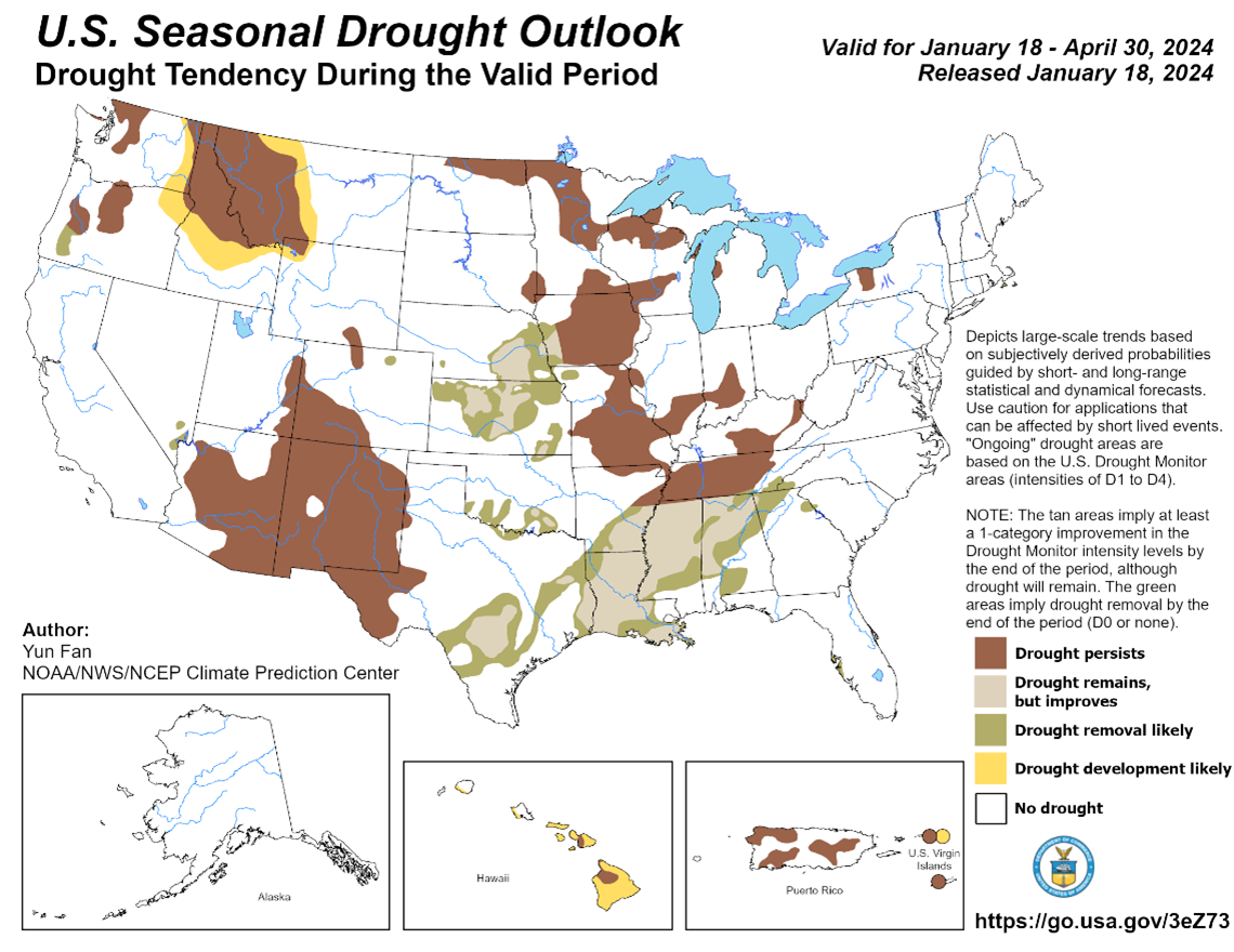
One- and three-month predictive outlooks from NOAA’s Climate Prediction Center (CPC) predict average to above-average temperatures through April with equal chances for above or below-average precipitation. The CPC’s official three-month drought outlook (Figure 3) for late winter and early spring predicts the persistence of drought conditions as there is not a strong likelihood for the above-average precipitation needed to end the drought. However, it is important to acknowledge that there is still significant uncertainty surrounding weather predictions at monthly to seasonal timescales. Forecasters and climatologists will closely monitor the El Niño Southern Oscillation (ENSO) status as we are expected to rapidly transition from strong El Niño to La Niña conditions in 2024. While composites of previous La Nina events don’t provide a strong signal for seasonal conditions in Missouri, it is hopeful that a pattern switch could help reverse the trend of warmer and drier weather experienced in 2023.

References
1NOAA National Centers for Environmental information, Climate at a Glance: Statewide Time Series, published January 2024, retrieved on January 26, 2024 from https://www.ncei.noaa.gov/access/monitoring/climate-at-a-glance/statewide/time-series
2American Meteorological Society, 2020: Climatology. Glossary of Meteorology, http://glossary.ametsoc.org/wiki/climatology.
3https://droughtimpacts.unl.edu/Tools/ConditionMonitoringObservations.aspx
4https://dnr.mo.gov/about-us/forums-stakeholder-groups/drought-assessment-committee
